|
Bolivia : Potosí
5.5 km (3.4 miles) ESE of Tambo, Potosí, Bolivia
Approx. altitude: 3700 m
(12138 ft)
([?] maps: Google MapQuest OpenStreetMap ConfluenceNavigator)
Antipode: 21°N 113°E
Accuracy: 10 m (32 ft)
Quality: good
Click on any of the images for the full-sized picture.
| 21°S 67°W |

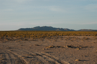
(visited by ARTURO ECHALAR) 26-Sep-2005 -- This confluence point was visited during our reconnaissance trip (looking for places for installing GPS continuous Stations) in a project between IGM (Instituto Geografico Militar) Bolivia and OSU (Ohio State University) USA, the people who were traveling were Mike Bevis (OSU) Mario Sandoval, Arturo Echalar and Roger Tinta, the point it was exactly on the west of the second class road, going from New San Cristobal Town – Photo 1, (close to San Cristobal Mine), to Uyuni.
The Photo 1 is showing the North direction from the confluence point, this is an arid area Altiplanic zone, with 3.800 meters ASL a temperatures between -25C to +25C.
|
| All pictures |
| #1: North Direction #2: East Direction #3: South Direction #4: West Direction #5: Over the Point #6: Mario, Mike and David #7: San Cristobal ALL: All pictures on one page |


