|
United States : Michigan
18.8 miles (30.2 km) NW of Grand Beach, Berrien, MI, USA
Approx. altitude: 176 m
(577 ft)
([?] maps: Google MapQuest OpenStreetMap topo aerial ConfluenceNavigator)
Antipode: 42°S 93°E
Accuracy: 32.0 km (19.9 mi)
Quality:
Click on any of the images for the full-sized picture.
| 42°N 87°W (visit #2) | (incomplete) |
 (visited by Joseph Kerski) 16-Apr-2019 -- As I was in the Chicago area teaching about geotechnologies, including GIS, GPS, and remote sensing, a confluence visit seemed like the perfect capstone. The opportunity presented itself when I took a field trip to the Indiana Dunes National Lakeshore with geomorphology students from Valparaiso University. Valparaiso University is almost due south of the confluence point near the 87th Meridian. In fact, 87 passes by the campus about 1 mile to the east. We arrived at the dunes in early afternoon on a spring day. Unfortunately, no boats were available to rent, and the distance was too far for a closer approach to the confluence point. Nevertheless, it was a fine day to be on the dunes, looking toward the point, and learning about glacial, lake, river, and other processes acting upon the landscape. The temperature stood at about 65 F under breezy sunny skies. The Indiana Dunes are a marvel to behold, so high and unexpected. It would have been more productive to get over to Michigan City and see if anyone would be willing to take me to the confluence point, and also to start out earlier in the day. |
| All pictures |
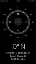
| #1: Looking north toward 42 North 87 West from the shore of Lake Michigan in Indiana. #2: GPS reading at the closest approach to the confluence. #3: Joseph Kerski thinking about the confluence point. #4: Walking down the sand dune toward the shore south of the confluence point. #5: The sand dune facing the confluence point. ALL: All pictures on one page |
| Notes |
|
In Lake Michigan, about 19 mi from shore. |


![Visit #1: [29-Jun-07] Visit #1: [29-Jun-07]](/us/mi/n42w087/preview.jpg)