|
Mexico : Baja California Norte
2.2 km (1.4 miles) SE of Los Carapilas, Baja Calif. Norte, Mexico
Approx. altitude: 2 m
(6 ft)
([?] maps: Google MapQuest OpenStreetMap ConfluenceNavigator)
Antipode: 32°S 65°E
Accuracy: 5 m (16 ft)
Quality: good
Click on any of the images for the full-sized picture.
| 32°N 115°W |

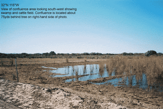
(visited by Michael Wheeley) 19-Jan-2002 -- I rode out from San Diego on Saturday Jan19th by motorcycle but managed to get lost in Mexicali so didn't arrive near the confluence area until about 4:30pm, unfortunately this being January it was starting to get dark. I managed to get to about 1mile from the site and stopped to get a few photos of the spectacular sunset over the mountains to the west. I had brought along a compact tent stuffed into by panniers and was hoping to rough it thinking this would be in the middle of no-where, several miles off-road on a dusty trail. But as I was stopped a jeep came speeding up the trail, evidently my noisy single cylinder had drawn some attention and now the Mexican military had come to check me out. They slowly rolled past and circled at a distance a couple of times, so I decided I was definitely not welcome here after dark. Do they patrol for illegal squatters, or is this drug smuggling territory, I'm not sure but probably should have checked earlier - time to leave. 20-Jan-2002 -- The next day I got up and onto the road early knowing I'd have to make the trip back down south to the confluence, find it and then return back to San Diego by bike all in one day. It was almost a perfect day, not a cloud in the sky although a moderate breeze was blowing from the north occasionally whipping up dust. Southbound on the Hwy5 I passed a small pack of cyclists making a fair pace all in their team colors out for their Sunday morning run. Having been to the area the day before I was able to navigate straight to the site. About 20miles south of Mexicali the Hwy4 heads east towards Coahuila. This is flat land, river delta, cultivated sandy-clay soil agricultural. After slowing a couple of times for small roadside communities the highway reaches a modern crossing over a gentle Rio Colorado, a river only a fraction of it's mighty self further upstream. Just a few miles further busy market day Sunday, the town of Coahuila. The route to the confluence is not immediately obvious, from the center of town the road south is black-top but this road eventually leads to a dead-end. Continuing a couple of blocks to the east and then south the road is worn to a dusty trail but this improves and becomes a road again about a half mile ahead as it exits the town. After about 5 miles the road reaches a T-junction and a small rural community not marked on any maps. About two miles from the confluence it was now necessary to go off-road by taking the trail directly ahead then several hundred yards later a right fork along a sandy track that seems to go straight towards the point. Unfortunately with about a half-mile to go and at the edge of a large barren field an irrigation ditch bars the route with a tree crossing for pedestrians only, an interesting on a gusty windy day! There's is no doubt another way to the farm-track on the other side but being now so close I hid the bike and started to walk. Approaching the site I thought for a moment I'd be having to get wet feet, but fortunately the spot lays in a cattle pasture about 30yards from the edge of an enclosed swamp. I would imagine that after any rain this area floods very easily. I located the confluence by GPS and took photos of the surroundings and of the mountains about twenty miles to the west. Then without too much delay I retraced my steps and headed back to the bike and home. It was now about lunch time on Sunday Jan20th 2002, I was cruising north-bound on Baja Norte Hwy5 about 15 miles south of Mexicali. Ahead the light traffic was slowing, emergency vehicles were blocking the right hand lane, a highway patrol officer directing traffic to slowly pass to the left. As I passed at no more than a walking pace in the middle of the right hand lane a white sheet was draped over a body, red blood soaking through the sheet and running out over the road. On the back of an open police truck just ahead sat several cyclists, the same as I had passed southbound less than a couple of hours before, they sat in shock and grief at the loss of one of their friends. Rest In Peace brave warrior. |
| All pictures |
| #1: View of confluence area #2: View from confluence looking east #3: View from confluence looking south #4: View from confluence looking west #5: Nearby irrigation channel and crossing #6: Nearby field, view of mountains towards the west #7: GPS ALL: All pictures on one page |


