
| { Main | Search | Countries | Information | Member Page } | |
United States : Texas; showing visits by Richard Rutledge |
| There are no Plans for this Region. |
| Region Notes |
|
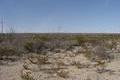
31°N 103°W 10.2 miles (16.4 km) NW of Fort Stockton, Pecos, TX, USA [28-Jan-03] |
|
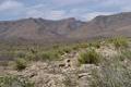
31°N 104°W 15.2 miles (24.4 km) W of Balmorhea (Reeves), Jeff Davis, TX, USA [02-May-02] |

|
33°N 96°W 3.5 miles (5.6 km) W of Lone Oak, Hunt, TX, USA [15-Oct-00] |

|
33°N 98°W 2.8 miles (4.5 km) NNE of Whitt, Parker, TX, USA [06-Aug-00] |

|
32°N 98°W 2.3 miles (3.7 km) NE of Hico, Hamilton, TX, USA [10-Jul-00] |

|
32°N 97°W 2.1 miles (3.5 km) N of Bynum, Hill, TX, USA [15-Jun-00] |
Region Notes:
The Texas Department of Transportation has their Texas Official Travel Map available for download as a PDF file. The map includes latitude/longitude grid tic marks that have been placed at the Degree Confluences. Information on the map projections used in Texas can be found at the TNRIS website.